Explore Hamilton County Ohio GIS data and unlock powerful CAGIS mapping tools for parcels, property records, zoning, and land use insights. Through the CAGIS Internet Map Server, Hamilton County Online Mapping System, and Open Data Hub, users can access interactive maps, download shapefiles, and analyze parcel polygons, tax maps, and building footprints. From the Auditor’s Property Search to survey plats and zoning PDFs, discover accurate, up-to-date geospatial data for research, planning, and real estate decisions.
Step 1 – Open the CAGIS Internet Map Server for Interactive Mapping
Start by visiting the CAGIS Internet Map Server to view Hamilton County parcel maps, satellite imagery, street layouts, and topographic layers. This interactive GIS platform supports real-time mapping, permitting workflows, and public service coordination, helping users visually analyze property boundaries, land use classifications, and infrastructure data.
Step 2 – Use Hamilton County Online Mapping System for Detailed Views
Next, access the Hamilton County Online Mapping System to switch between base maps such as aerial photography, topo maps, and road networks. This browser-based GIS application lets you zoom into neighborhoods, identify parcels, measure distances, and overlay multiple data layers for accurate spatial analysis.
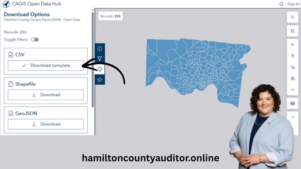
Step 3 – Download Shapefiles from the CAGIS Open Data Hub
Visit the CAGIS Open Data Hub to download public GIS datasets including parcel polygons, building footprints, contours, and zoning layers. These shapefiles are ideal for planners, researchers, and real estate professionals who need raw geospatial data for mapping software, spatial modeling, or custom analysis.
Step 4 – Search Property Records via Hamilton County Auditor Portal
Use the Hamilton County Auditor’s Property Search to find parcel numbers, tax maps, ownership details, and land use codes. Simply enter an address or parcel ID to access official property records, assessed values, and mapping links, making it easier to verify real estate data and taxation information.
Step 5 – Access Survey, Plat, and Zoning Maps for Specialized Data
For advanced mapping needs, explore Survey & Tax Maps from the County Engineer, Recorder’s Office plat maps, and the Map Shop PDF collection. These resources provide subdivision plats, township maps, zoning layouts, and field notes, offering precise boundary information and historical land records.
Types of Parcel Data Available in Hamilton County
Hamilton County offers parcel data in multiple formats to serve different user needs, from casual property lookups to professional data analysis.
GIS Parcel Data
GIS (Geographic Information System) parcel data allows users to view property boundaries on interactive maps. This format is ideal for visual analysis, zoning checks, and boundary verification.
CSV Parcel Data
CSV (Comma-Separated Values) files provide structured parcel information that can be downloaded and analyzed in Excel or Google Sheets. This format is commonly used by investors, analysts, and researchers.
Other Available Formats
- Shapefiles for advanced GIS software
- Online parcel search tools
- Bulk data downloads for large-scale analysis
Understanding Hamilton County GIS Parcel Data
GIS parcel data visually represents each parcel on a digital map. Users can zoom, pan, and click on parcels to access detailed property information.
What GIS Maps Show
- Parcel boundaries and lot lines
- Parcel numbers and addresses
- Land use and zoning layers
- Nearby infrastructure and roads
GIS tools are especially helpful for surveyors, planners, developers, and real estate professionals.
Understanding CSV Parcel Data and How It’s Used
CSV parcel data provides property details in table format, making it easy to sort, filter, and analyze.
Typical CSV Parcel Data Fields
| Field Name | Description |
|---|---|
| Parcel Number | Unique property identifier |
| Owner Name | Current recorded owner |
| Property Address | Physical location |
| Land Value | Assessed land value |
| Building Value | Assessed structure value |
| Total Value | Combined assessed value |
| Tax District | Applicable tax area |
CSV data is widely used for market analysis, tax comparison, and investment research.
How to Access Hamilton County Parcel Data
Parcel data can be accessed directly through official county resources.
Online Access Methods
- Property search by address
- Search by parcel number
- Owner name search
- Interactive GIS map tools
Most online services are available 24/7 and free to use for public access.
Hamilton County Auditor Office Contact & Timing
For in-person assistance or official inquiries, the Hamilton County Auditor’s Office can be contacted during regular business hours.
Office Information
| Detail | Information |
| Office | Hamilton County Auditor |
| Business Days | Monday to Friday |
| Office Hours | 8:00 AM – 4:00 PM (EST) |
| Online Services | Available 24/7 |
| Services Offered | Parcel records, tax data, GIS support |
Online access is recommended for faster results, while in-person visits are useful for complex cases.
Common Tables Found in Parcel Records
Parcel data is typically displayed using structured tables for clarity.
Standard Parcel Tables
- Parcel Information Table
- Ownership History Table
- Tax Assessment Table
- Land Use Classification Table
- GIS Attribute Table
These tables allow users to quickly understand property details without technical expertise.
Limitations and Possible Drawbacks
While parcel data is highly valuable, users should be aware of certain limitations.
Possible Limitations
- Data updates may have delays
- GIS data may require technical understanding
- Not a substitute for legal or survey services
- Boundary lines may not replace official surveys
Understanding these limitations helps users interpret the data responsibly.
Who Should Use Hamilton County Parcel Data?
Parcel data is useful for a wide range of users.
Ideal Users
- Home buyers and sellers
- Real estate agents and brokers
- Property investors
- Surveyors and planners
- Researchers and analysts
Best Practices for Using Parcel Data Effectively
To get the most value from parcel data, users should rely on official sources and verify critical information.
Recommended Practices
- Use official county websites
- Double-check data accuracy
- Understand usage and licensing rules
- Respect privacy and legal guidelines
Conclusion
Hamilton County Ohio parcel data is a powerful public resource that supports transparency, informed decision-making, and accurate property research. By using GIS maps, CSV files, and official parcel tables correctly, users can gain valuable insights into property ownership, value, and land use. Whether accessed online or through the Auditor’s Office, parcel data remains a trusted foundation for real estate, taxation, and planning decisions.
FAQs
Is Hamilton County parcel data free to access?
Yes, most parcel records, GIS maps, and basic property details are available to the public for free. Some bulk or specialized data downloads may have usage conditions.
What is GIS parcel data and how is it used?
GIS parcel data displays property boundaries on interactive maps. It is used for zoning checks, land surveys, development planning, and visual property analysis.
What information is included in Hamilton County CSV parcel data?
CSV parcel data typically includes parcel numbers, owner names, property addresses, assessed land value, building value, total value, and tax district information.
How accurate is Hamilton County parcel and GIS data?
Parcel data is highly reliable but may not reflect real-time updates. GIS boundaries are for reference and do not replace certified land surveys.
Can parcel data be used for real estate investing?
Yes, investors use parcel data to analyze property values, ownership trends, tax assessments, and neighborhood patterns before making buying decisions.
What are the office hours for the Hamilton County Auditor?
The v Auditor’s Office is generally open Monday to Friday, 8:00 AM to 4:00 PM (EST). Online parcel search tools are available 24/7.
Does parcel data show property tax information?
Yes, parcel records include assessed values and tax district data used to calculate property taxes in Hamilton County.
Is Hamilton County parcel data legally binding?
Parcel data is an official public record, but it should not be used as a substitute for legal advice, title searches, or professional land surveys.